SECONDE : WATER, A VITAL RESOURCE
WATER SUPPLIES
Introduction: Water is an important resource on Earth. But 1 billion inhabitants have not got drinking water and 2.2 million people die each year either because water is poisoned or because they have not got enough water. Moreover, this resource is fragile and we need to take care of it.
KQ : Why is water a vital resource?
I) Resources are uneven
A°) A 'water world'
- water represents 72% of the world surface. But 97% of it is salted. Only 3% is spring water but sometimes it cannot be used for instance when it is stored in the islandis.
B°) with various sources
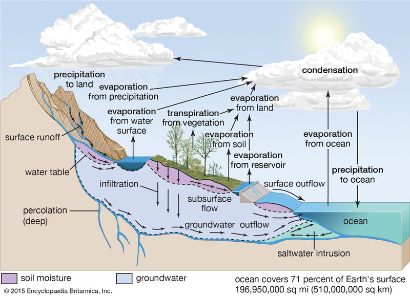
The hydrological cycle
The distribution of water can be explained by the evaporation and the precipitations. Solar energy contributed to the evaporation process.
- Lakes are the most important storage (123 000 Km3). Sometimes they are so large that they are like internal seas. Ex : Baikal Lake in Russia.
- Rivers are play also an important role on every continent. Some are giant. Ex : the Amazon river has the highest rate of flow (40 times the Nile's).
- aquifer (water-bearing) water - table are not easy to find out. They may represent 10 million Km3 = 90% of the resources we could use. These resources are stable, and non polluted but sometimes not easy to reach.
C°) but inequalities
The distribution of water can be explained because of the climate. That's why tropical areas have large resources instead some face a shortage of water : a water stress. Global warming is widening the gap between the countries.
In fact, the contrast between the countries is sharp. Iceland for instance has got 500 000 m3/inha./year whereas Koweit has only 7m3/inha/year.
To finish with there is a gap between MEDCs and LEDCs. In rich countries there is running water and either the quality and the quantity is fine whereas in poor countries water is not always drinkable and its access is sometimes uneasy.
II) A resource under control ?
A°) development and water consumption
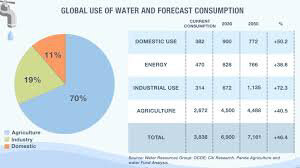
Graph : the consumption of water and uses of water
QUESTIONS:
1. Introduce, describe and comment upon that source.
ANSWERS :
Graph : the consumption of water and uses of water
The water consumption has increased because of the demographic growth and because of new needs. Since 1950s' the consumption has doubled.
Agriculture represents the first use of water, then industries and to finish with domestic use. The ration is 70% / 20% / 10%. Of course there are differences according to the continents.
graph : according to continents
Economic and historical factors can explained those features. MEDCs / LEDCs = industries and domestic but also hydraulic civilizations : rice culture but also floods. traditional societies based on water control.
B) New buildings
Case study : the Yangtze River and the three Gorges Dam
Source 1 : The Flood hazard
« The Yangtze is the third longest river in the world. It rises on the Tibetan Plateau and flows 6380 km to the East China Sea, just north of Shanghai. Although always prone to flooding, the frequency and intensity have increased in recent times and the effects have become greater as population and human activity in the basin have grown.
1931 : 140 000 deaths and estimated 28 to 40 millions affected. 1954 : 33 000 deaths
1981 and 1991 : both floods submerge large areas
1995 : 1300 deaths and up to 100 million affected
1998 : Worst flood for over half a century with 3000 deaths. 5.6 homes washed away. 30 million made homeless and huge areas of crops destroyed.
1999 : 240 deaths. 1.84 million evacuated and 660 000 ha of cropland flooded »
Source 2 : Main figures
QUESTIONS :
What are the impacts of the dam?
- Economic
- Social
- Cultural
- Environmental
Economic impacts :
- The huge deepwater reservoir allows navigation ( 2250 km inland)
- It produces hydroelectricity and reduces the use of coal
- Water can used for irrigation
Social impacts :
- It protects people from periodic flooding
- Danger of dam collapse
- Displacement of some 1.3 million people (1500 towns and cities and villages) Cultural impacts
- destruction of magnificent scenery
- destruction of rare architectural and archaeological sites
Environmental impacts
- pollution from industrial waste
- the huge amount of water in the reservoir could trigger earthquakes and landslides - destruction of species : animals and plants
C°) Distribution of activities
Case study : Water management in the Nile Basin
Source 1 : Aswan High Dam and Lake Nasser
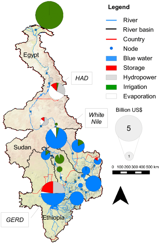
Source 2 : The multipurpose function of the Nile
Source 3 : ‘Greening the desert’
« Egypt’s population continues to grow at such a rapid rate that is has doubled since the opening of the Aswan Dam (33 millions in 1971, 100 millions in 2020, an estimated 159 millions by 2050). with an increasing number of mouths to feed, urban sprawl devouring 1% of the richest land in the delta each year, and every cultivated hectare having to support 28 people, it is not surprising (...) that ‘greening the desert’ is less a dream than a necessity’. 40 years ago the 200 km road from Cairo to Alexandria ran through a desert. Now it is bordered by factories and drip-irrigation fields.
In October 1997, (...) the Al-Salam, or Peace, canal was opened. This canal takes water from the Nile into the north of the Sinai Peninsula. It is hopes that by early 21st century :
- water from the canal will irrigate 240,000 hectares of desert.
- people will migrate here rather than, as at present, to Cairo.
- less cultivated land in the Nile Valley and delta will need to be built upon.
The major concern is that, as the flow of the Nile is depleted, salinization and coastal erosion may increase. A more ambitious scheme, the New Delta Project, would send water from Lake Nasser on a 500 km journey to link a string of desert oases. If successful up to 600,000 hectares could be used to produce food. »
Adapted from David Waugh, The new Wider World, Nelson 1998.
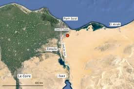
Source 4 : How to conquer a strategic area : the Al-Salam Canal in Sinai - Satelite image from the Nasa
Questions :
1. When was the Assouan dam built? Why? Source 1 and 2
2. Describe the distribution of the Nile River. Source 2
3. Which main projects have been built along the Nile? What for? Source 2 4. Why water could be a source of tensions? Source 2
5. What are the natural conditions prevailing in Egypt? source 3
6. Why are irrigation projects considered necessary? Source 3
7. Describe source 4 . are the consequences of the Al-Salam Canal in Sinaï.
Source 4 : How to conquer a strategic area : the Al-Salam Canal in Sinai Satelite image from the Nasa
Questions :
1. When was the Assouan dam built? Why? Source 1 and 2
2. Describe the distribution of the Nile River. Source 2
3. Which main projects have been built along the Nile? What for? Source 2 4. Why water could be a source of tensions? Source 2
5. What are the natural conditions prevailing in Egypt? source 3
6. Why are irrigation projects considered necessary? Source 3
7. Describe source 4 . are the consequences of the Al-Salam Canal in Sinaï
ANSWERS :
The Nile is the world’s longest river (6995 km) but nearly all its water comes from just three tributaries - the White Nile, the Blue Nile and the Atbara - and for the last 2700 m of its journey to the Mediterranean Sea, it flows through desert land. The blue Nile and the Atbara rise in the Ethiopian Highlands were the six months of heavy rainfall are responsible’s for the Nile’s annual flood. Under the 1959 Nile Agreement, the flow is partitioned between Egypt and Sudan on a 75-25% basis. From 1960 to 1971 Egypt built the High Dam in Aswan with funds from the nationalization of the Suez canal and a loan from the USSR. The project brought about the creation of Lake Nasser, a 132 billion m3, 500 km-long artificial storage water lake.
But eight counties - all with high birth rates and potentially large demands on water - lie in the White Nile basin. In 1999, the ten riparians joined to create the Nile Basin Initiative, a regional partnership to facilitate the common pursuit of sustainable development and management of the Nile waters. Yet managing the water of a river crisscrossing several countries can be a source of conflict.
Agriculture ranks first in terms of national water consumption. States lacking adequate water supply, have to manage their insufficient resources and sometimes built huge projects.
The Sinai is a desert peninsula occupied by Israel in 1967 and returned to Egypt in 1979. The Egyptian government has decided a gigantic project (canal Al-Salam) to fulfill economic development upsetting environmentalists and populations who feared displacement. Ever since Antiquity the Nile has made it possible to irrigate Egypt and to meet the demands of a growing population.
CONCLUSION :
Make a flow chart entitled : Water supplies
Use the boxes : Uneven needs (LEDCs MEDCs)
Rise in consumption (demographic growth and activities) Water Stress
Tensions between areas (on various scales)
Threats on resources (quality - quantity) Fresh water at disposal
Equipments (energy, irrigation, transport...)
Uneven needs Equipments fresh water at disposal
HOMEWORK : Tuesday May, 12th.
Choose a picture related, according to you, to global water issues and comment upon it.


/https%3A%2F%2Fassets.over-blog.com%2Ft%2Fcedistic%2Fcamera.png)
/https%3A%2F%2Fstorage.canalblog.com%2F21%2F33%2F1624309%2F129056081_o.jpeg)
/https%3A%2F%2Fstorage.canalblog.com%2F65%2F26%2F1624309%2F128946767_o.jpeg)